• Services
    • Geotechnical Investigations
    • Landslides
    • Soil Testing
    • Groundwater
    • Wastewater
    • Coasts
    • Contaminated Sites
  • Products
    • Cromer Hydrogeological Calculators
    • Cromer Constant Head Field Permeameter
    • Trench® Wastewater Software
  • About
  • News
    • News Archive
  • Publications
    • Cromer Reports Database
  • Contact me

Bill Cromer

Home » News » An unusual boulder spit at Dennes Point on Bruny Island

An unusual boulder spit at Dennes Point on Bruny Island

March 5, 2015 by Bill Cromer Leave a Comment

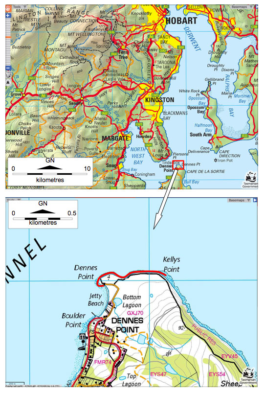
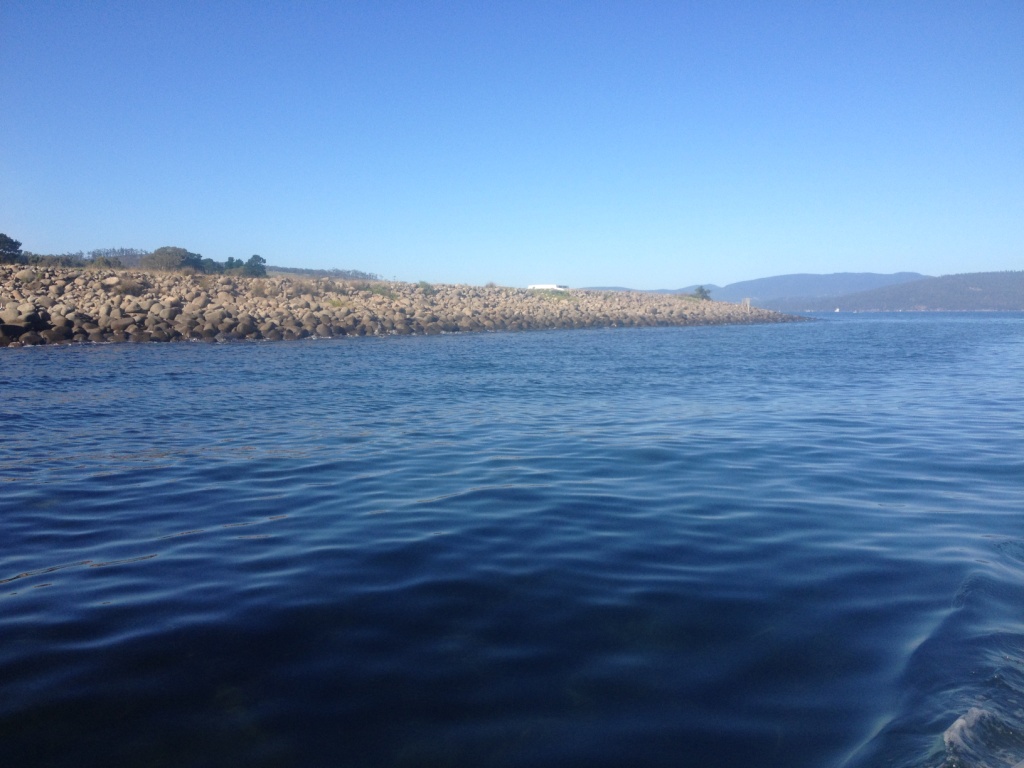
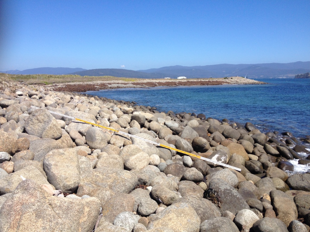
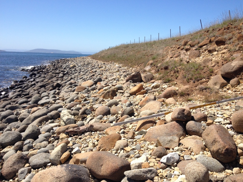
I’m collaborating with expert coastal geologist/geomorphologist Chris Sharples to report on an unusual occurrence of boulders at the extreme northern tip of Bruny Island in southern Tasmania. The rounded, moderately-graded, mostly dolerite boulders (and cobbles) up to half a metre or so in size form an arcuate foreshore several metres high and extending a few hundred metres east from Dennes Point past Kellys Point.

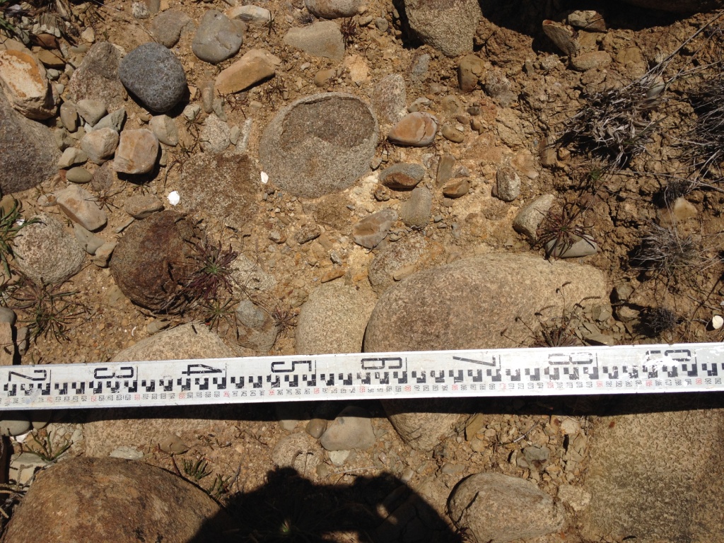
Conservatively, some 15,000t of loose cobbles and boulders are exposed. About 10% of the material is Permian-age siltstone and sandstone cobbles and boulders, eroded from coastal cliffs and shore platforms to the east.

Recent coastal erosion has exposed dolerite boulders and cobbles present under sand on neighbouring beaches to the south, and a spit of dolerite boulders has formed between low and high water mark on Boulder Point.

Some say the boulder deposit is man-made – possibly ballast left by ships. A moment’s reflection shows this can’t be true: on the world stage, dolerite is a rare rock and is hardly likely to have been carried from overseas in large amounts by arriving ships; furthermore, departing vessels would either be in cargo or ballast, and if the latter, would hardly have dumped it just after leaving Hobart for the open sea. In any case, rounded boulders are scarcely a safe cargo in a rolling ship.

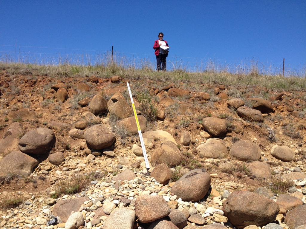
Dolerite boulders occur elsewhere on foreshores on the western side of the Derwent Estuary – notably from Taroona north to near Blinking Bill Point at Sandy Bay – where they are clearly being winnowed out of Tertiary-age boulder beds. On the northern tip of Bruny Island, Chris thinks the arcuate form of the boulder deposits wrapping around Kellys and Dennes Points is a rare recurved boulder spit, probably formed from winnowed boulders moved by storm swells refracting into the northern end of D’Entrecasteaux Channel.

Recurved sandy spits are a relatively common feature on the Tasmanian coast, but are rare in material as coarse as these boulders.

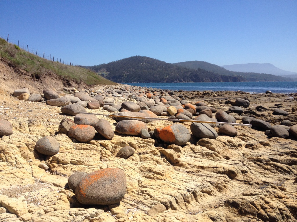
Locally, the boulders appear to be actively eroding from a weakly cemented conglomerate on Kellys Point. I think the conglomerate was formerly much more extensive, is probably Tertiary in age, and was the source material for the recurved spit.

Two maps showing the location of Dennes Point, the northern-most township on Bruny Island
The location of Dennes Point, the northern-most township on Bruny Island, Tasmania
Dennes Point, looking south from the entrance to D’Entrecasteaux Channel. The dolerite boulders forming the spit curving away along the channel stand several metres above high water mark.
Dennes Point, looking south from the entrance to D’Entrecasteaux Channel in February 2015. The dolerite boulders forming the spit curving away from the camera along the channel stand several metres above high water mark.
Dolerite boulders at Dennes Point, looking west from Kellys Point. The staff in the foreground is 5m long.
Dennes Point, looking west from Kellys Point. The dolerite boulders slope seawards at about 15°. The staff in the foreground is 5m long.
Dennes Point, looking west from Kellys Point showing the dolerite boulder deposit extending inland from the foreshore and disappearing beneath grass cover. The seawards slope here is about 250.
Dennes Point, looking west from Kellys Point. The dolerite boulder deposit extends inland from the foreshore, disappearing beneath grass cover and more recent Holocene aeolian sand. The seawards slope here is about 25°. The staff in the foreground is 3m long.
At Kellys Point, looking south to a weakly-cemented orange-brown boulder and cobble bed of rounded dolerite clasts, smaller angular sandstone and siltstone clasts, in a silt/sand matrix.
Kellys Point, looking south up to a weakly-cemented orange-brown boulder and cobble bed (a conglomerate) consisting of rounded dolerite clasts, and smaller angular sandstone and siltstone clasts, in a silt/sand matrix. Boulders are actively being eroded from the bank. I think the boulder bed might be Tertiary in age, that it was formerly much more extensive, and is the source of the material making up the recurved spit.
Detail of the (possibly) Tertiary conglomerate on Kellys Point, Bruny Island. A staff with values in decimetres is placed on the ground for scale.
Detail of the Tertiary? conglomerate on Kellys Point. The numbers on the staff are decimetres.
Looking east from Kellys Point, past the Tertiary? conglomerate at right, with sandstone and siltstone clasts on the foreshore. A 2.5m long staff is placed in the foreground for scale.
Looking east from Kellys Point, past the Tertiary? conglomerate at right. Sandstone and siltstone clasts on the foreshore become relatively more common to the east. The staff is 2.5m long.

Looking west towards Kellys Point, from a shore platform cut into Permian siltstone and sandstone showing the eastern extent of the dolerite boulders.
Looking west towards Kellys Point, from a shore platform cut into Permian siltstone and sandstone. This location marks the eastern extent of the dolerite boulders.

Filed Under: Vulnerable Coasts and Sea Levels

Leave a Reply Cancel reply

Your email address will not be published. Required fields are marked *

Subscribe to my newsletter
Profile of Bill Cromer

Geologist, thylacine author, tennis player [more about me].

Contact Bill

  • Email
  • Google+
  • Twitter

PH 0408 122 127

INT +61 408 122 127

Recent Posts

  • Codes in the 2015 Tasmanian Interim Planning Scheme
  • Flowchart for applying the Tasmanian Acid Sulphate Soils Code
  • Flowchart for applying the Tasmanian Coastal Erosion Hazard Code
  • Tasmanian Landslide Code
  • Tasmanian On-site Wastewater Management Code

News Archive

View full archive

News Archive by Month

  • August 2016 (3)
  • May 2016 (2)
  • August 2015 (1)
  • June 2015 (2)
  • March 2015 (7)
  • February 2015 (1)
  • July 2014 (2)
  • June 2014 (1)
  • March 2014 (1)
  • December 2013 (2)
  • November 2013 (1)
  • October 2013 (6)
  • July 2013 (3)
  • May 2013 (2)

Professional Services

  • Geotechnical Investigations
  • Soil Testing
  • Groundwater
  • Wastewater
  • Coasts

Products

  • Cromer Hydrogeological Calculators
  • Cromer Constant Head Field Permeameter
  • Trench® Wastewater Software

News Categories

  • Apps & Software
  • Cromer Permeameter
  • General
  • Geology
  • Geotechnical Investigations
  • Groundwater
  • Landslides
  • Thylacine
  • Vulnerable Coasts and Sea Levels
  • Wastewater
  • Home
  • Professional Services
  • Products
  • About
  • News
  • Publications
  • Contact me

Contact

  • Email
  • Google+
  • Twitter

PH 0408 122 127

INT +61 408 122 127

Copyright ©2025 Bill Cromer. All Rights Reserved.