• Services
    • Geotechnical Investigations
    • Landslides
    • Soil Testing
    • Groundwater
    • Wastewater
    • Coasts
    • Contaminated Sites
  • Products
    • Cromer Hydrogeological Calculators
    • Cromer Constant Head Field Permeameter
    • Trench® Wastewater Software
  • About
  • News
    • News Archive
  • Publications
    • Cromer Reports Database
  • Contact me

Bill Cromer

Home » News » A new occurrence of Tertiary boulder beds in Glenorchy, Tasmania

A new occurrence of Tertiary boulder beds in Glenorchy, Tasmania

March 4, 2015 by Bill Cromer Leave a Comment

Downloads

  • Hydrogeology Borehole Log for a site in Glenorchy, Tasmania [PDF 25 KB]

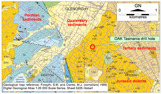
The published 1:25,000 scale digital geological map of the Hobart metropolitan area shows the OAK Tasmania’s Walkabout Industries site in Clydesdale Street, Glenorchy, and the neighbourhood, to be underlain by Jurassic-age dolerite.

New field evidence suggests the map needs to be amended.

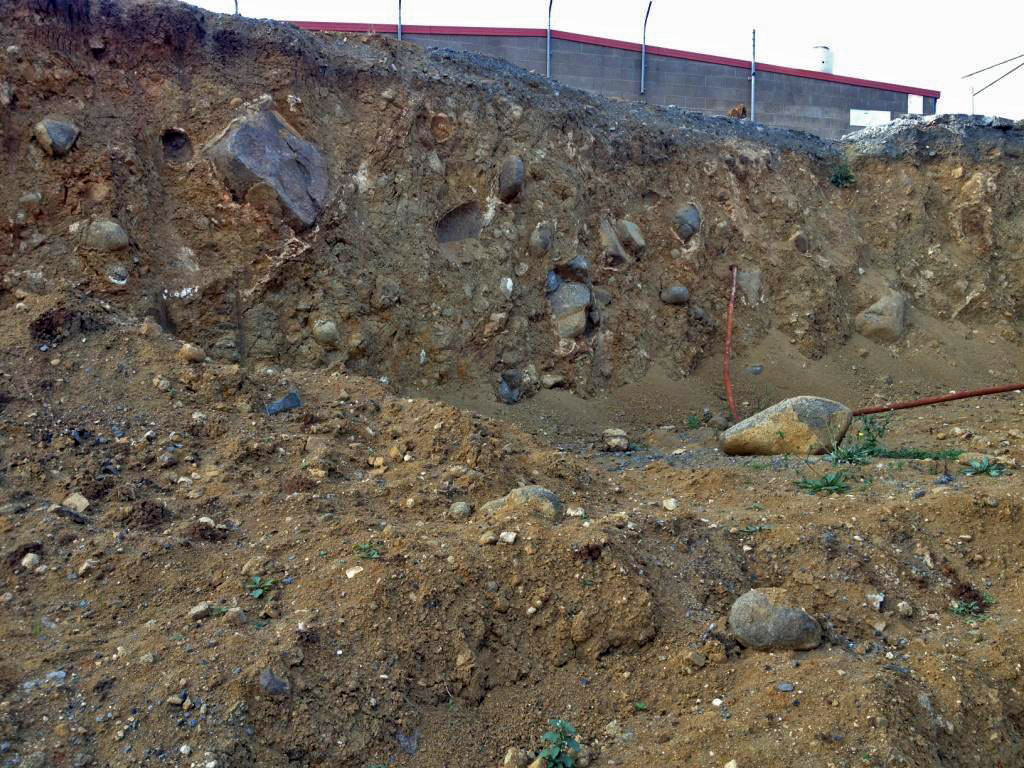
In 2011 bulk excavations at OAK provided excellent exposures of weakly-consolidated, orange-brown boulder beds (see photo). The clasts in the material are almost entirely angular to rounded dolerite cobbles and boulders up to about 0.5m in size, with a few percent of smaller clasts of chert, and Parmeener Supergroup siltstone and sandstone.

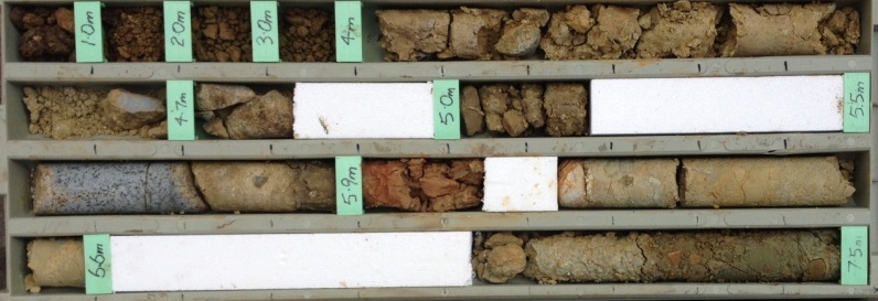
In July 2013, a 9.6m deep auger-and-diamond drill hole sited adjacent to the excavation encountered 5.6m of similar doleritic boulder beds, overlying conglomerate composed entirely of Parmeener Supergroup sandstone and siltstone clasts to 50mm in a non-plastic silt/sand/gravel matrix. A band of pink/orange silty clay occurred in the conglomerate over the 5.90-6.05m depth interval. See the photo of the core, and the log of the hole.

I interpret the deposits in the excavation and drill hole to be Tertiary in age and of similar fault-scarp related origin to other boulder beds in the Hobart district. I think the thin horizon of silty clay in the drill hole could be volcanic ash. It is not clear how far the Tertiary deposits extend laterally from the OAK Tasmania site.

1:25000 scale geological map of glenorchy showing Permian, Quaternary, Tertiary and Jurassic dolerite zones
Geological map reference: Forsyth, S.M. and Clarke, M.J. (compilers) 1999. Digital Geological Atlas 1:25 000 Scale Series. Sheet 5225 Hobart

Excavations have exposed weakly-consolidated, orange-brown Tertiary boulder beds
Boulder beds with mostly dolerite clasts in an excavation at the OAK Tasmania’s Walkabout Industries site in Clydesdale Street, Glenorchy. The exposure is about 3m high.

Samples from each of the deposits found at different depths in the core from a drill hole in a Tertiary age boulder bed
The core from a 9.6m deep auger-and-diamond drill hole sited adjacent to the excavation. To 5.9m, the boulder beds are dominated by dolerite clasts. Below about 6.15m, the clasts are wholly Parmeener Supergroup sandstone and siltstone. I interpret the intervening pink/orange silty clay as volcanic ash, and the deposit as a whole as Tertiary in age.

Filed Under: Geotechnical Investigations

Leave a Reply Cancel reply

Your email address will not be published. Required fields are marked *

Subscribe to my newsletter
Profile of Bill Cromer

Geologist, thylacine author, tennis player [more about me].

Contact Bill

  • Email
  • Google+
  • Twitter

PH 0408 122 127

INT +61 408 122 127

Recent Posts

  • Codes in the 2015 Tasmanian Interim Planning Scheme
  • Flowchart for applying the Tasmanian Acid Sulphate Soils Code
  • Flowchart for applying the Tasmanian Coastal Erosion Hazard Code
  • Tasmanian Landslide Code
  • Tasmanian On-site Wastewater Management Code

News Archive

View full archive

News Archive by Month

  • August 2016 (3)
  • May 2016 (2)
  • August 2015 (1)
  • June 2015 (2)
  • March 2015 (7)
  • February 2015 (1)
  • July 2014 (2)
  • June 2014 (1)
  • March 2014 (1)
  • December 2013 (2)
  • November 2013 (1)
  • October 2013 (6)
  • July 2013 (3)
  • May 2013 (2)

Professional Services

  • Geotechnical Investigations
  • Soil Testing
  • Groundwater
  • Wastewater
  • Coasts

Products

  • Cromer Hydrogeological Calculators
  • Cromer Constant Head Field Permeameter
  • Trench® Wastewater Software

News Categories

  • Apps & Software
  • Cromer Permeameter
  • General
  • Geology
  • Geotechnical Investigations
  • Groundwater
  • Landslides
  • Thylacine
  • Vulnerable Coasts and Sea Levels
  • Wastewater
  • Home
  • Professional Services
  • Products
  • About
  • News
  • Publications
  • Contact me

Contact

  • Email
  • Google+
  • Twitter

PH 0408 122 127

INT +61 408 122 127

Copyright ©2025 Bill Cromer. All Rights Reserved.