• Services
    • Geotechnical Investigations
    • Landslides
    • Soil Testing
    • Groundwater
    • Wastewater
    • Coasts
    • Contaminated Sites
  • Products
    • Cromer Hydrogeological Calculators
    • Cromer Constant Head Field Permeameter
    • Trench® Wastewater Software
  • About
  • News
    • News Archive
  • Publications
    • Cromer Reports Database
  • Contact me

Bill Cromer

Home » News » Archives for July 2014

Archives for July 2014

Mt Wellington rockfall

July 26, 2014 by Bill Cromer Leave a Comment

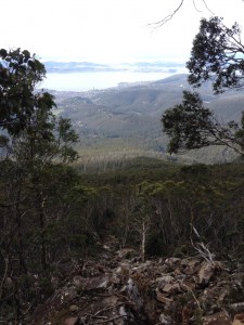
On 8 July, Hobart City Council asked me to assess the risk posed to road users and track walkers from a large dolerite boulder (50t) which had toppled off a small cliff section on steep (40+degree) slopes on Mt Wellington. Despite the millions of already-toppled boulders on the adjacent talus slopes, geological time is immense and rockfalls are rare enough to be noteworthy.  This boulder was also larger than most, and since it did not break up, its travel path was longer than most. It came to rest in a muddy bouldery watercourse 170m downslope, about 20m across the Pinnacle Track.

I arrived at the site a few hours after the fall. With daylight hours fading, and uncertain about the boulder’s stability, I though we ought to close the Pinnacle Road to the summit of the mountain. Council organised this immediately.

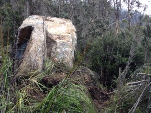
Next morning, after a Council crew cleared scrub from around our rock, it was clear that the boulder had come to rest against other smaller ones. I thought the potential for it to remobilise was “unlikely’, and the risk to life to a road user 300m downslope was “tolerable”.  Pinnacle Road was reopened, and we instigated a set of monitoring points around the boulder to further assess its stability.

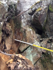
A scramble uphill by me and Matt Lindus (Council’s Acting Manager of Bushland & Reserves) found the source – an empty 2.5m wide space between two smaller but similarly leaning boulders. We temporarily closed Pinnacle Track while I reviewed slope stability issues, runout distances and hillside slopes. Overnight, I satisfied myself that the risk to track users was also “tolerable”, and recommended that the track be reopened. We’ll be looking to see what measures (if any) are needed to reduce the likelihood of the two remaining boulders toppling. Monitoring shows that the fallen boulder seems to have stabilised.

My risk assessments included reference to the Australian Geomechanics Society series of volumes on Landslide Risk Management (2007), and to the good work being done by Colin Mazengarb and Michael Stevenson at our local Mineral Resources Tasmania. They’ve produced a series of Landslide Hazard Maps for major population centres in Tasmania. (The Potential Rockfall Hazard Map for Hobart not surprisingly identifies the steep slopes of Mt Wellington as at risk of rockfalls, but it also shows that Pinnacle Track, and most others, are at risk of runout of boulders across them.) I also had valuable discussions with Victorian geotechnical engineer Tony Miner, my erudite sounding board for more than a handful of landslide issues.

I suspect that if a detailed assessment was done of walking tracks on the mountain, the risks to walkers would range from “acceptable” through “tolerable” to “unacceptable”. But closing high risk tracks would no doubt be a very unpopular move. Maybe we should redefine what we mean by acceptable and unacceptable risk for activities which are inherently riskier than others, but in which we willingly and knowingly engage.
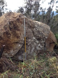
The 50 tonne dolerite boulder. The staff is 3m high.
The 50 tonne dolerite boulder on 9 July 2014. The staff is 3m high.
The 50 tonne dolerite boulder, at rest against other smaller boulders, on 9 July 2014.
The 50 tonne dolerite boulder, at rest against other smaller boulders, on 9 July 2014. The string line was set up to monitor any forward toppling movement, but in fact the boulder settled backwards a few millimetres in the days after the fall.
The 2.5m wide gap left by the fallen boulder, between two other similarly leaning boulders, at 1,000m elevation.
The 170m travel path taken by the boulder, over 40+0 talus slopes and through 250 sub-alpine eucalypt forest slopes.

Filed Under: Geotechnical Investigations

Should geotechnical practitioners be accredited?

July 22, 2014 by Bill Cromer Leave a Comment

People (like me) who conduct geotechnical (including landslide) investigations and write geotechnical reports ought to be qualified to do so. At the very least, in Tasmania, we must have a university degree in Engineering, Geotechnical Engineering or Geology, and have Professional Indemnity Insurance (Certificates of Specialists or Other Persons).

In Tasmania, twenty or so firms or individuals advertise in this important field, but only a handful are active. Like professionals everywhere, we exhibit a range of geotechnical expertise, from poor, to OK, to good.

So there is room for improvement. But how?

It’s not easy. Under the current situation, most of us are already “suitably qualified”, yet some are clearly out of our depth and continue to churn out poor work. We have lots of help – ready access to excellent guidance from the Australian Geomechanics Society (AGS), one of the leading geotechnical organisations in the country. (Most local Councils demand that geotechnical reports are done in accordance with AGS Guidelines.)

But some of us pay only lip service to the guidelines. Local Councils are continually frustrated recipients of substandard geotechnical reports, and ask for peer reviews.

In this competitive consulting world, some of us charge cheaply to attract work. Low prices restrict our ability to do extra work if the job requires it, and in turn beget more substandard work. We should never underquote, or even quote, for geotechnical work.

Through long experience I can guarantee that these wise words will fall mostly on deaf ears.

So. Should we be accredited?

Filed Under: Geotechnical Investigations

Subscribe to my newsletter
Profile of Bill Cromer

Geologist, thylacine author, tennis player [more about me].

Contact Bill

  • Email
  • Google+
  • Twitter

PH 0408 122 127

INT +61 408 122 127

Recent Posts

  • Codes in the 2015 Tasmanian Interim Planning Scheme
  • Flowchart for applying the Tasmanian Acid Sulphate Soils Code
  • Flowchart for applying the Tasmanian Coastal Erosion Hazard Code
  • Tasmanian Landslide Code
  • Tasmanian On-site Wastewater Management Code

News Archive

View full archive

News Archive by Month

  • August 2016 (3)
  • May 2016 (2)
  • August 2015 (1)
  • June 2015 (2)
  • March 2015 (7)
  • February 2015 (1)
  • July 2014 (2)
  • June 2014 (1)
  • March 2014 (1)
  • December 2013 (2)
  • November 2013 (1)
  • October 2013 (6)
  • July 2013 (3)
  • May 2013 (2)

Professional Services

  • Geotechnical Investigations
  • Soil Testing
  • Groundwater
  • Wastewater
  • Coasts

Products

  • Cromer Hydrogeological Calculators
  • Cromer Constant Head Field Permeameter
  • Trench® Wastewater Software

News Categories

  • Apps & Software
  • Cromer Permeameter
  • General
  • Geology
  • Geotechnical Investigations
  • Groundwater
  • Landslides
  • Thylacine
  • Vulnerable Coasts and Sea Levels
  • Wastewater
  • Home
  • Professional Services
  • Products
  • About
  • News
  • Publications
  • Contact me

Contact

  • Email
  • Google+
  • Twitter

PH 0408 122 127

INT +61 408 122 127

Copyright ©2025 Bill Cromer. All Rights Reserved.