• Services
    • Geotechnical Investigations
    • Landslides
    • Soil Testing
    • Groundwater
    • Wastewater
    • Coasts
    • Contaminated Sites
  • Products
    • Cromer Hydrogeological Calculators
    • Cromer Constant Head Field Permeameter
    • Trench® Wastewater Software
  • About
  • News
    • News Archive
  • Publications
    • Cromer Reports Database
  • Contact me

Bill Cromer

Home » News » Archives for August 2016

Archives for August 2016

Codes in the 2015 Tasmanian Interim Planning Scheme

August 17, 2016 by Bill Cromer Leave a Comment

I’ve recently posted news items about the Tasmanian Landslide Code, the On-site Wastewater Management Code, and the Coastal Erosion Hazard Code. I’ve produced flowcharts to help people navigate through each of these.

Many people I am sure are unaware of these Codes, and 20 or more others, which form part of Tasmania’s state-wide 2015 Interim Planning Scheme. Potentially, they affect if and how you develop your land. If you are planning a development – it might be building a new house, or extending an existing one – you should check them out beforehand.

If you are contemplating buying land to build on, I would also strongly suggest that the contract for purchase should include a clause which says that settlement is subject to a satisfactory geotechnical report.

Here’s the full list of Codes in the 2015 Interim Planning Scheme, labelled E1.0 though to E24.0. Not all of them apply to each Local Council. The ones I can help you with are linked to pages in this website.

E1.0
Bushfire-Prone Areas Code
E2.0
Potentially Contaminated Lands Code
E3.0
Landslide Code
E4.0
This code number not used
E5.0
Road and Railways Assets Code
E6.0
Parking and Access Code
E7.0
Stormwater Management Code
E8.0
Electricity Transmission Infrastructure Protection Code
E9.0
Attenuation Code
E10.0
Biodiversity Code
E11.0
Waterway and Coastal Protection Code
E12.0
This code number not used
E13.0
Historic Heritage Code
E14.0
Scenic Landscapes Code
E15.0
Inundation Prone Areas Code
E16.0
Coastal Erosion Hazard Code
E17.0
Signs Code
E18.0
Wind and Solar Energy Code
E19.0
Telecommunications Code
E20.0
Acid Sulphate Soils Code
E21.0
Dispersive Soils Code
E22.0
This code number not used
E23.0
On-site Wastewater Management Code
E24.0
Significant Trees Code

You can also see the Codes listed, and in detail, on the state government website www.iplan.tas.gov.au.

(Click on “Planning Schemes”, then select your Local Council, and, at left, “Part E Codes”.)
Filed Under: Geotechnical Investigations

Flowchart for applying the Tasmanian Acid Sulphate Soils Code

August 15, 2016 by Bill Cromer Leave a Comment

I’ve produced a PDF flowchart to help people navigate through the Tasmanian Acid Sulphate Soils Code.

The Code is one of many in the 2015 Interim Planning Scheme used by all Tasmanian Local Councils. See the list of Codes including the ones for which I offer professional services.

Potentially acid sulphate soils or sediments are naturally-occurring materials which contain microscopic particles of dark-coloured (mainly iron) sulphides. The sulphides were formed by sulphate-reducing bacteria acting on original sulphate in sea water.

Environments favourable for their formation are oxygen-poor (reducing) conditions in former or present day mud flats and other low-lying or shallow submarine coastal areas. Some potentially acid sulphate soils occur at higher elevations.

When disturbed and exposed to the atmosphere, the sulphides in these soils or sediments re-oxidise to sulphates and produce sulphuric acid solutions. The acid mobilises metals in the soil which in turn can cause environmental or infrastructure issues at the disturbed site, or elsewhere if seepages flow into adjacent waterways.

Importantly, if these materials are left undisturbed, sulphate is not generated. This is the key to their management.

Undisturbed soils with the potential to form acid sulphate are called PASS. Once disturbed, they are Actual Acid Sulphate Soils (AASS). Collectively these materials are called Acid Sulphate Soils (ASS).

The Tasmanian Department of Primary Industry, Parks, Water and Environment (DPIPWE) has plenty of information on where ASS occur in Tasmania, and how to manage them (PDF document). You can also check online to see if land you are interested in is in an ASS zone.

Go to the state government website www.thelist.tas.gov.au. On the home page, click “LISTmap”; double click on the location of interest and continue to double click (or use the mouse wheel) to zoom in; click “Layers” at top right, then click “Add Layer +”. In the menu box that opens, scroll down to “Geology and Soils”, click on “Soils” and click on one of the four Acid Sulphate Soils (the circular green + icons”. You may need to zoom in further until the bands are visible. Drag the menu box out of the way (or close it). At top right of the screen, click on the tiny arrow in the Acid Sulphate Soils box to see the Legend and change the transparency.

Filed Under: Geotechnical Investigations

Flowchart for applying the Tasmanian Coastal Erosion Hazard Code

August 12, 2016 by Bill Cromer Leave a Comment

I’ve produced a PDF flowchart to help people navigate through the Tasmanian Coastal Erosion Hazard Code.

The Code aims to mitigate the risk to life and property due to coastal erosion, recession and wave run-up under current and future sea level change. It is one of many in the 2015 Interim Planning Scheme used by all Tasmanian Local Councils. See the list of Codes including the ones for which I offer professional services.

The Code applies to development applications (like new houses) for waterfront properties which are in Coastal Erosion Hazard bands. The bands denote susceptibility of a coast to erosion, and are coloured red (high erosion hazard), orange (medium) or yellow (low). A few coastal areas are coloured green (“Coastal erosion investigation area”) where the level of erosion susceptibility is uncertain and requires further investigation.

Read about how bands are defined and mapped around Tasmania’s coastline in the very comprehensive 2013 coastal erosion report (PDF document) by Chris Sharples, Hannah Walford and Luke Roberts, and issued by the Tasmanian Department of Premier and Cabinet (DPAC).

If you are thinking about buying waterfront land and/or building a house on it, you are strongly advised to check its erosion hazard banding on the state government website www.thelist.tas.gov .au

On the home page, click “LISTmap”; double click on the location of interest and continue to double click (or use the mouse wheel) to zoom in; click “Layers” at top right, then click “Add Layer +”. In the menu box that opens, scroll down to “Coasts and Oceans and Estuaries”, click on “Coastal Vulnerability” and click on the circular green + icon for “Coastal Erosion Hazard Bands”. You may need to zoom in further until the bands are visible. Drag the menu box out of the way (or close it). At top right of the screen, click on the tiny arrow in the “Coastal Erosion Hazard Bands” box to see the Legend and change the transparency.

Some development applications are exempt from the Code.

If the Code applies to an application, your Local Council will require “more information” before approving or rejecting it.

The flowchart is designed to help everyone understand the situations in which the Code applies, and what Local Councils require in order to consider a development application in a Coastal Erosion Hazard band. Generally speaking, some form of reporting by a “Suitably Qualified Person” is needed. (The qualifications or experience of this person are not defined, but I regard myself as one) Site investigations – of a mainly geotechnical nature – may be required before a report can be prepared.

Local Council may approve or reject a report (and your development application). If approved, complying with the requirements of the Code may add costs to your proposed development.

If you think your proposed development might be in a Coastal Erosion Hazard band, you should get its accuracy checked in the field by a suitably qualified person. This is because on the www.thelist.tas.gov.au website, DPAC states “…Hazard bands as depicted in this map may not accurately represent the existence or otherwise of hazards in the mapped area. Independent expert advice should be sought if action is to be taken that may be impacted by the existence or otherwise of hazards in the mapped area.”

Checking the accuracy of a Coastal Erosion Hazard band is done primarily by site inspection to review the topography and geology of the property and environs, and perhaps undertaking subsurface investigations on it.

I’ve heard that some real estate agents are unaware of the Coastal Erosion Hazard bands, and the Code, so be alert.

Other Codes may potentially affect your development application. These include but may not be restricted to the On-site Wastewater Management Code, the Landslide Code, and the Acid Sulphate Soils Code. I provide advice on these three Codes. See my May 2016 news posts about them, and the accompanying flowcharts I’ve produced for them.

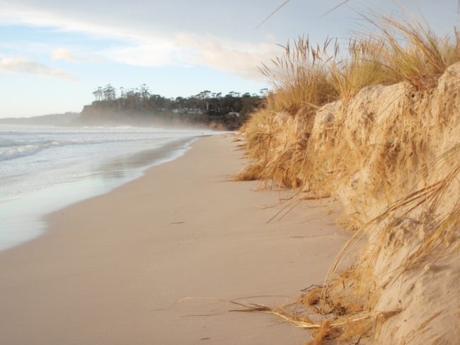
A 1.5m high erosion scarp at Spring Beach near Orford in southeastern Tasmania.
In September 2009, storm waves at Spring Beach near Orford produced an erosion scarp 1.5m high. The beach is a “soft” shoreline and is in the red (high) Coastal Erosion Hazard band.
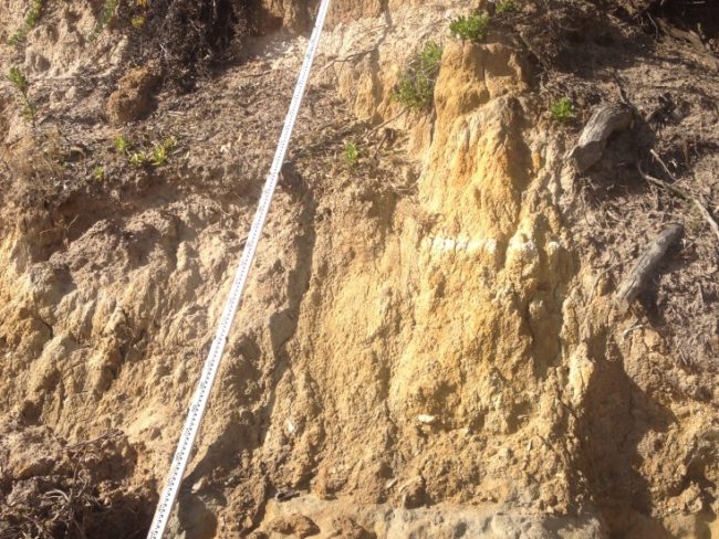
The vertical face of a 5m high actively eroding soft shoreline
A 5m high active erosion scarp on a “soft” shoreline of unconsolidated sediments in southeastern Tasmania. The shoreline is in a green (uncertain) Coastal Erosion Hazard band. Site investigations amended the banding to red backed inland by orange and yellow.
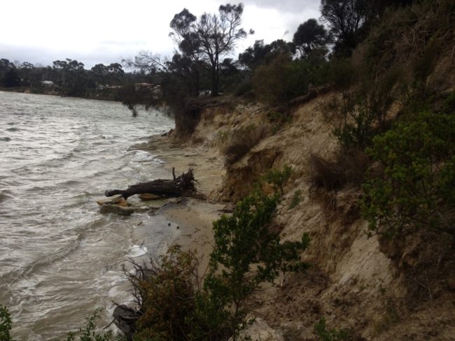
An actively eroding, soft shoreline at Dodges Ferry in southeastern Tasmania
An actively eroding “soft” shoreline at Dodges Ferry in southeastern Tasmania is in the green (uncertain) Coastal Erosion Hazard band. Resistant and “hard” sandstone bedrock visible at sea level rises inland beneath erodible sediments. This observation, and investigations for a new house 50m inland, demonstrated that the house site was not at risk of erosion and should be placed in the “Acceptable” band. It would then be exempt from the Coastal Erosion Hazard Code.

Filed Under: Vulnerable Coasts and Sea Levels

Subscribe to my newsletter
Profile of Bill Cromer

Geologist, thylacine author, tennis player [more about me].

Contact Bill

  • Email
  • Google+
  • Twitter

PH 0408 122 127

INT +61 408 122 127

Recent Posts

  • Codes in the 2015 Tasmanian Interim Planning Scheme
  • Flowchart for applying the Tasmanian Acid Sulphate Soils Code
  • Flowchart for applying the Tasmanian Coastal Erosion Hazard Code
  • Tasmanian Landslide Code
  • Tasmanian On-site Wastewater Management Code

News Archive

View full archive

News Archive by Month

  • August 2016 (3)
  • May 2016 (2)
  • August 2015 (1)
  • June 2015 (2)
  • March 2015 (7)
  • February 2015 (1)
  • July 2014 (2)
  • June 2014 (1)
  • March 2014 (1)
  • December 2013 (2)
  • November 2013 (1)
  • October 2013 (6)
  • July 2013 (3)
  • May 2013 (2)

Professional Services

  • Geotechnical Investigations
  • Soil Testing
  • Groundwater
  • Wastewater
  • Coasts

Products

  • Cromer Hydrogeological Calculators
  • Cromer Constant Head Field Permeameter
  • Trench® Wastewater Software

News Categories

  • Apps & Software
  • Cromer Permeameter
  • General
  • Geology
  • Geotechnical Investigations
  • Groundwater
  • Landslides
  • Thylacine
  • Vulnerable Coasts and Sea Levels
  • Wastewater
  • Home
  • Professional Services
  • Products
  • About
  • News
  • Publications
  • Contact me

Contact

  • Email
  • Google+
  • Twitter

PH 0408 122 127

INT +61 408 122 127

Copyright ©2025 Bill Cromer. All Rights Reserved.