I’ve recently been researching landslide triggers in Tasmania. Events which trigger landslides include unusually heavy rainfall events, and earthquakes.
Here’s a graph of some 860 earthquakes and their magnitudes recorded in the Tasmanian region over the period 1958 – 2014. It’s a picture of quiet earthquake periods lasting several years interrupted by years of much more intense activity.
The information is freely available on the Geoscience Australia website.
If you are able to access Google Earth (you will need the Google Earth software for PC, Mac or Linux), you can see the distribution of the same earthquakes on the satellite image of Tasmania in the .kmz file below. (I’m an IT amateur: David Winkle at A. S. Miner Geotechnical set up the .kmz file for me.)
Instructions for viewing the file are as follows:
- Click on the Google Earth file – satellite image of distribution of earthquakes in Tasmania. Depending on your browser, this will download the file or instantly open it in Google Earth. In the former case, you’ll need to locate the file in your file manager and then open it in Google Earth.
- Left-clicking on an earthquake symbol on the satellite image provides more detailed information.
A very similar map of earthquake epicentres in the Tasmanian region appears in the beautifully comprehensive Geological Evolution of Tasmania (2014) published by the Tasmanian Division of the Geological Society of Australia.
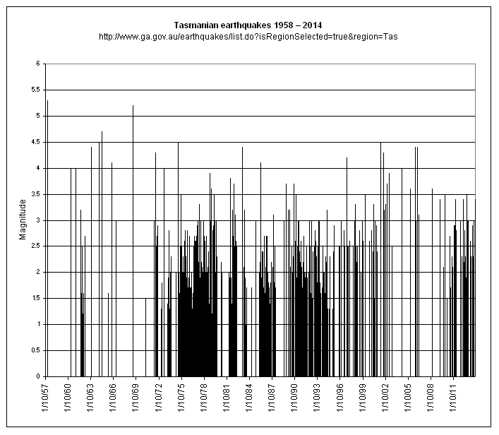
Information about earthquake magnitudes is summarised in the two tables following. (The estimated number of earthquakes each year in the first table is the worldwide number.) The Tasmanian earthquakes range in magnitude class from (less than) Minor to Light, with two quakes (in January 1958 and May 1969) of magnitudes 5.3 and 5.2 respectively edging into the Moderate class. Earthquake activity not shown on the graph and map included many small and some large quakes in northeastern Tasmania during 1883 – 1885.
Earthquake Magnitude Scale
| Magnitude | Earthquake Effects | Estimated Number Each Year |
|---|---|---|
| 2.5 or less | Usually not felt, but can be recorded by seismograph. | 900,000 |
| 2.5 to 5.4 | Often felt, but only causes minor damage. | 30,000 |
| 5.5 to 6.0 | Slight damage to buildings and other structures. | 500 |
| 6.1 to 6.9 | May cause a lot of damage in very populated areas. | 100 |
| 7.0 to 7.9 | Major earthquake. Serious damage. | 20 |
| 8.0 or greater | Great earthquake. Can totally destroy communities near the epicenter. | One every 5 to 10 years |
Earthquake Magnitude Classes
Earthquakes are also classified in categories ranging from minor to great, depending on their magnitude.
| Class | Magnitude |
|---|---|
| Great | 8 or more |
| Major | 7 – 7.9 |
| Strong | 6 – 6.9 |
| Moderate | 5 – 5.9 |
| Light | 4 – 4.9 |
| Minor | 3 -3.9 |
Leave a Reply