• Services
    • Geotechnical Investigations
    • Landslides
    • Soil Testing
    • Groundwater
    • Wastewater
    • Coasts
    • Contaminated Sites
  • Products
    • Cromer Hydrogeological Calculators
    • Cromer Constant Head Field Permeameter
    • Trench® Wastewater Software
  • About
  • News
    • News Archive
  • Publications
    • Cromer Reports Database
  • Contact me

Bill Cromer

Home » News » General

New scar on kunanyi/Mt Wellington

August 25, 2015 by Bill Cromer Leave a Comment

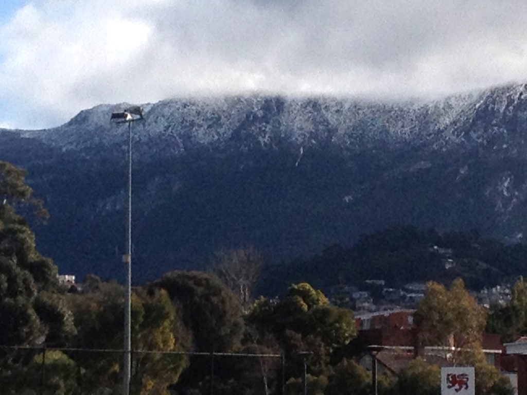
The new scar on our majestic mountain is the white dribble down its flank, below the snowline and just right of centre, in the accompanying photo.

A little over a year ago, in July 2014, a 50 tonne boulder tipped over at the top of this dribble, and tumbled down the steep slope for about 170m. On the way it flattened hundreds of small alpine eucalypts, gouged soil, and halted just over the Pinnacle Track.  It’s path is hard to see most of the time, but in winter, snow preferentially accumulates and persists along the route, making this newest, natural scar plain to see. I’m surprised our avid mountain observers haven’t commented on it. Read more about the event in my news posted last year just after it happened.

A new scar on Mt Wellington (photo taken August 24, 2015)
A new scar on kunanyi/Mt Wellington. Photo taken August 24, 2015 from the Derwent Sailing Squadron on the Derwent River.

Can I call it “Bill’s Dribble”?

There are plenty of other, older scars on the mountain, relics of past slope movement. I think our new mountain dribble will slowly disappear over the next several decades. There are no other similar ones visible, suggesting that falling rocks of this size don’t happen very often.

Filed Under: General

New? aboriginal “relics” in southern Tasmania

March 5, 2015 by Bill Cromer Leave a Comment

In my travels around coastal Tasmania I often come across aboriginal middens – many (but not all) of which are probably included in the list of 12,000 or so cultural sites on the Aboriginal Heritage Register (AHR). [The AHR replaced the Tasmanian Aboriginal Site Index (TASI) in 2014.]

The Register is maintained by Aboriginal Heritage Tasmania (AHT) a division of the Department of Primary Industries, Parks, Water and Environment (DPIPWE). The fundamental aims of AHT “are to protect, conserve and promote Tasmania’s unique Aboriginal heritage for the benefit of present and future generations of Tasmanians.”

Physical evidence of aboriginal heritage is a “relic”, the management of which comes under the Aboriginal Relics Act 1975. This Act is likely to be replaced by the Aboriginal Heritage Protection Bill, which broadens the definition of “relics” to “Aboriginal objects” and “Aboriginal places”, each of which are of “significance to Aboriginal persons”.

I understand that members of the public don’t have direct access to the Register, so without formally approaching AHT it is not clear to me whether the following two aboriginal places have already been discovered and officially recorded:

  • Place #1 is a small near-coastal aboriginal quarry I stumbled on close to one of Hobart’s eastern suburbs. The quarried material is a light grey, very hard and flinty chert – possibly of Tertiary age – showing clear signs of scalloping and chipping.
  • Place #2 is an aboriginal worksite for quarried materials on a sandstone boulder beach in eastern Tasmania. The quarry is probably close by to the south. The quarried material is a dark grey, hard, indurated (baked) mudstone (some with light-olive siltstone laminations). Perhaps a few tonnes are scattered along about 50m of foreshore between high and low water marks. Apart from unworked angular blocks weighing up to a few kilograms, worked items are mainly smaller discarded flakes, chips and fragments, but some show good evidence of further hand-scalloping towards scrapers. Most have been tumbled about by wave action and are becoming rounded and smoothed. A few on the grassy verge out of reach of waves are more angular. A rounded strongly chipped hammer stone was also present. A single, angular tan-coloured scraper looks out of place among rounded cobbles. Was it recently dropped?

Very hard and flinty chert in one of Hobart’s eastern suburbs. The rock shows clear signs of scalloping and chipping.
Place #1. Very hard and flinty chert in one of Hobart’s eastern suburbs. The rock shows clear signs of scalloping and chipping.
Place #2.  On this Tasmanian east coast intertidal zone, all the dark rock fragments – all of them waterworn – are hard, baked mudstone relics carried from a nearby aboriginal quarry. Along this 50m or so stretch of foreshore, aborigines honed some of the rock fragments to tools, and discarded those seen here.
Place #2. On this Tasmanian east coast intertidal zone, all the dark rock fragments – all of them waterworn – are hard, baked mudstone relics carried from a nearby aboriginal quarry. Along this 50m or so stretch of foreshore, aborigines honed some of the rock fragments to tools, and discarded those seen here.
A discarded, moderately waterworn relic with scattered chips. A set of car keys has been used to show scale.
Place #2. A discarded, moderately waterworn relic with scattered chips.
A discarded, sharp-edged relic among sandstone cobbles and boulders above high water mark. A set of car keys has been used to indicate scale.
Place #2. A discarded, sharp-edged relic among sandstone cobbles and boulders above high water mark.
Discarded Aboriginal relics among sandstone cobbles and boulders near high water mark on a beach in eastern Tasmania. Carkeys used to show scale.
Place #2. Discarded relics among sandstone cobbles and boulders near high water mark.
A sharp-edged, tan-coloured scraper appears completely out of place in the intertidal zone on a southern Tasmania beach. A set of keys has been used to indicate scale.
Place #2. This sharp-edged, tan-coloured scraper appears completely out of place in the intertidal zone. Was it dropped recently?
 

Filed Under: General

Tasmanian shipwreck Annie Taylor

February 28, 2015 by Bill Cromer 1 Comment

Hilary and I recently holidayed at one of our Island Shacks at Spring Beach on Tasmania’s east coast. We drove south a few kilometres to lovely, deserted Rheban Beach and cycled 2.5km along it at low tide.

The beach is a mid-bay spit which grew by northeasterly accretion of sandy beach ridges during the last five thousand years or so (ie in the Holocene Epoch; extending from about 12,000 years ago to the Present).

At its northwestern corner, near where the long-gone Rheban jetty once projected out into Mercury Passage, we noticed ship’s timbers sticking out of the sand.

It’s almost certain these timbers are all that is left of the Annie Taylor, a 27m long ketch built in Melbourne in 1920, and wrecked at Rheban in November 1923. Almost a hundred years ago, Annie Taylor had loaded timber at the jetty. She was anchored offshore before leaving for Melbourne. A gale came up, she was blown ashore, and broke up slowly. Over the decades since, wave action and sand movement seem to have shifted her skeleton about.

Read more about her and hundreds of other Tasmanian shipwrecks in the beautifully-composed Tasmanian Shipwrecks (Volumes 1 and 2; 2013) by Graeme Broxam and Michael Nash. If you are travelling on Tasmania’s east coast, visit the township of Triabunna, and on the waterfront call in at the Spring Bay Maritime & Discovery Centre which has an Annie Taylor display.

Rheban Spit, Tasmania and the location of the former jetty and the Annie Taylor shipwreck
Rheban Spit, Tasmania, and the location of the Annie Taylor shipwreck

Tasmanian Shipwrecks. Volume Two 1900 – 1999, page 123. Roebuck Series Publication No. 54. Navarine Publishing."href="http://williamccromer.com/content/uploads/2015/03/annie-taylor-at-hobart.jpg" rel="prettyPhoto[post-gal]">Black and white image of the Annie Taylor docked at Hobart
Annie Taylor at Hobart. She was almost new when she was wrecked in 1923. Photo reproduced from: Broxam, G. and Nash, M. (2000). Tasmanian Shipwrecks. Volume Two 1900 – 1999, page 123. Roebuck Series Publication No. 54. Navarine Publishing.

Wrecks in Tasmanian Waters 1797 – 1950.Tasmanian Government Printer."href="http://williamccromer.com/content/uploads/2015/03/annie-taylor-at-rheban-beach-after-beaching.jpg" rel="prettyPhoto[post-gal]">Black and white photo of the Annie Taylor at Rheban Beach not long after beaching, with water and flotsam around her.
Annie Taylor on Rheban Beach – not long after beaching judging by the flotsam around her. Photo reproduced from: O’May, H. (1954; reprinted 1985). Wrecks in Tasmanian Waters 1797 – 1950.Tasmanian Government Printer.

http://snoopy2418fishingmannsbeach.blogspot.com.au/"href="http://williamccromer.com/content/uploads/2015/03/annie-taylor-at-rheban-beach-early-1920s.jpg" rel="prettyPhoto[post-gal]">Old black and white photo of the Annie Taylor shipwreck at Rheban Beach.
Annie Taylor on Rheban Beach, probably late 1923 or early 1924.
[Photo reproduced from: http://snoopy2418fishingmannsbeach.blogspot.com.au/

Marine Life (Issue 1, November 2009, page 31)"href="http://williamccromer.com/content/uploads/2015/03/annie-taylor-at-rheban-beach-1950.jpg" rel="prettyPhoto[post-gal]">Old black and white photo of the Annie Taylor shipwreck on Rheban Beach showing how she has shifted parallel to the shore, pointing northwest.
Annie Taylor on Rheban Beach in 1950. Over almost three decades she has shifted parallel to the shore, pointing northwest. Beach erosion has lowered her, and she has protected a short section of foredune on her leeward side. Photo reproduced from Marine Life (Issue 1, November 2009, page 31)

Tasmanian Shipwrecks. Volume Two 1900 – 1999, page 123. Roebuck Series Publication No. 54. Navarine Publishing."href="http://williamccromer.com/content/uploads/2015/03/annie-taylor-at-rheban-beach-1954.jpg" rel="prettyPhoto[post-gal]">Old black and white photo of men standing on the Annie Taylor shipwreck on Rheban Beach in 1954.
Annie Taylor on Rheban Beach in 1954. Photo reproduced from: Broxam, G. and Nash, M. (2000). Tasmanian Shipwrecks. Volume Two 1900 – 1999, page 123. Roebuck Series Publication No. 54. Navarine Publishing.

The Spring Bay Community Boatshed Snapshot 6 (February 2014)"href="http://williamccromer.com/content/uploads/2015/03/annie-taylor-at-rheban-beach-january-2014.jpg" rel="prettyPhoto[post-gal]">Annie Taylor at low tide on Rheban Beach in clear, blue water.
Annie Taylor at low tide on Rheban Beach, January 2014. [Photo reproduced from The Spring Bay Community Boatshed Snapshot 6 (February 2014)

Annie Taylor at low tide on Rheban Beach, showing waves breaking over the wreck.
Annie Taylor at low tide on Rheban Beach, February 2015.

Filed Under: General

Presenting this website at an EHA seminar

October 15, 2013 by Bill Cromer Leave a Comment

Mark Dwyer (National and State President, Environmental Health Australia) has invited me to present and talk about this website at an EHA professional development seminar at the Grange, Campbell Town, on December 4.

I’ll be continually adding new content to the site before the seminar, and will be covering issues such as the recently adopted Australian Standard 1547 (2012) On-site domestic wastewater management, my flowchart for on-site assessment, the two downloadable pdfs on wastewater systems, the status of Trench®3.0, the Cromer permeameter, my new permeability app for iPad and iPhone for iPad and iPhone, and other hydrology apps in the pipeline.

Filed Under: General

Exploring two geological world heritage sites

October 12, 2013 by Bill Cromer Leave a Comment

Just returned from a month touring in the UK, and made a point of stopping at Knockan Crag in the desolate, beautiful Scottish Highlands to climb up to, and poke my finger in, the Moine Thrust. Exciting. This is one of the most famous and studied geological outcrops on earth — its interpretation as a major overthrust (older rocks pushed over younger ones) was a critical step forward in early geological science.

Also could not resist a three day stay at the seaside resort of Lyme Regis on the famous Jurassic Coast in Dorset – the town that inspired The French Lieutenant’s Woman, the town that is England’s most popular fossil-hunting mecca, and the home of Mary Anning, 19th century fossil-hunter extraordinaire (“the greatest fossil hunter ever known”). Mary found the first ichthyosaur and plesiosaur skeletons, became world-famous in palaeontology, cemented Lyme Regis on the tourist map, and much more recently, was the real-life heroine of Tracey Chevalier’s best-selling historical novel Remarkable Creatures. A few days later, I was staring at one of Mary’s dinosaurs — still in its timber box — at the Sedgwick Museum of Earth Sciences in Cambridge, and soon after, on British TV, I watched an interview with Tracey Chevalier. Coincidences.

Filed Under: General

Subscribe to my newsletter
Profile of Bill Cromer

Geologist, thylacine author, tennis player [more about me].

Contact Bill

  • Email
  • Google+
  • Twitter

PH 0408 122 127

INT +61 408 122 127

Recent Posts

  • Codes in the 2015 Tasmanian Interim Planning Scheme
  • Flowchart for applying the Tasmanian Acid Sulphate Soils Code
  • Flowchart for applying the Tasmanian Coastal Erosion Hazard Code
  • Tasmanian Landslide Code
  • Tasmanian On-site Wastewater Management Code

News Archive

View full archive

News Archive by Month

  • August 2016 (3)
  • May 2016 (2)
  • August 2015 (1)
  • June 2015 (2)
  • March 2015 (7)
  • February 2015 (1)
  • July 2014 (2)
  • June 2014 (1)
  • March 2014 (1)
  • December 2013 (2)
  • November 2013 (1)
  • October 2013 (6)
  • July 2013 (3)
  • May 2013 (2)

Professional Services

  • Geotechnical Investigations
  • Soil Testing
  • Groundwater
  • Wastewater
  • Coasts

Products

  • Cromer Hydrogeological Calculators
  • Cromer Constant Head Field Permeameter
  • Trench® Wastewater Software

News Categories

  • Apps & Software
  • Cromer Permeameter
  • General
  • Geology
  • Geotechnical Investigations
  • Groundwater
  • Landslides
  • Thylacine
  • Vulnerable Coasts and Sea Levels
  • Wastewater
  • Home
  • Professional Services
  • Products
  • About
  • News
  • Publications
  • Contact me

Contact

  • Email
  • Google+
  • Twitter

PH 0408 122 127

INT +61 408 122 127

Copyright ©2025 Bill Cromer. All Rights Reserved.