• Services
    • Geotechnical Investigations
    • Landslides
    • Soil Testing
    • Groundwater
    • Wastewater
    • Coasts
    • Contaminated Sites
  • Products
    • Cromer Hydrogeological Calculators
    • Cromer Constant Head Field Permeameter
    • Trench® Wastewater Software
  • About
  • News
    • News Archive
  • Publications
    • Cromer Reports Database
  • Contact me

Bill Cromer

Home » News » Archives for March 2015

Archives for March 2015

Tasmania’s own geoguides

March 28, 2015 by Bill Cromer Leave a Comment

The Australian Geomechanics Society has published a series of Geoguides to help manage development on hillsides in Australia.

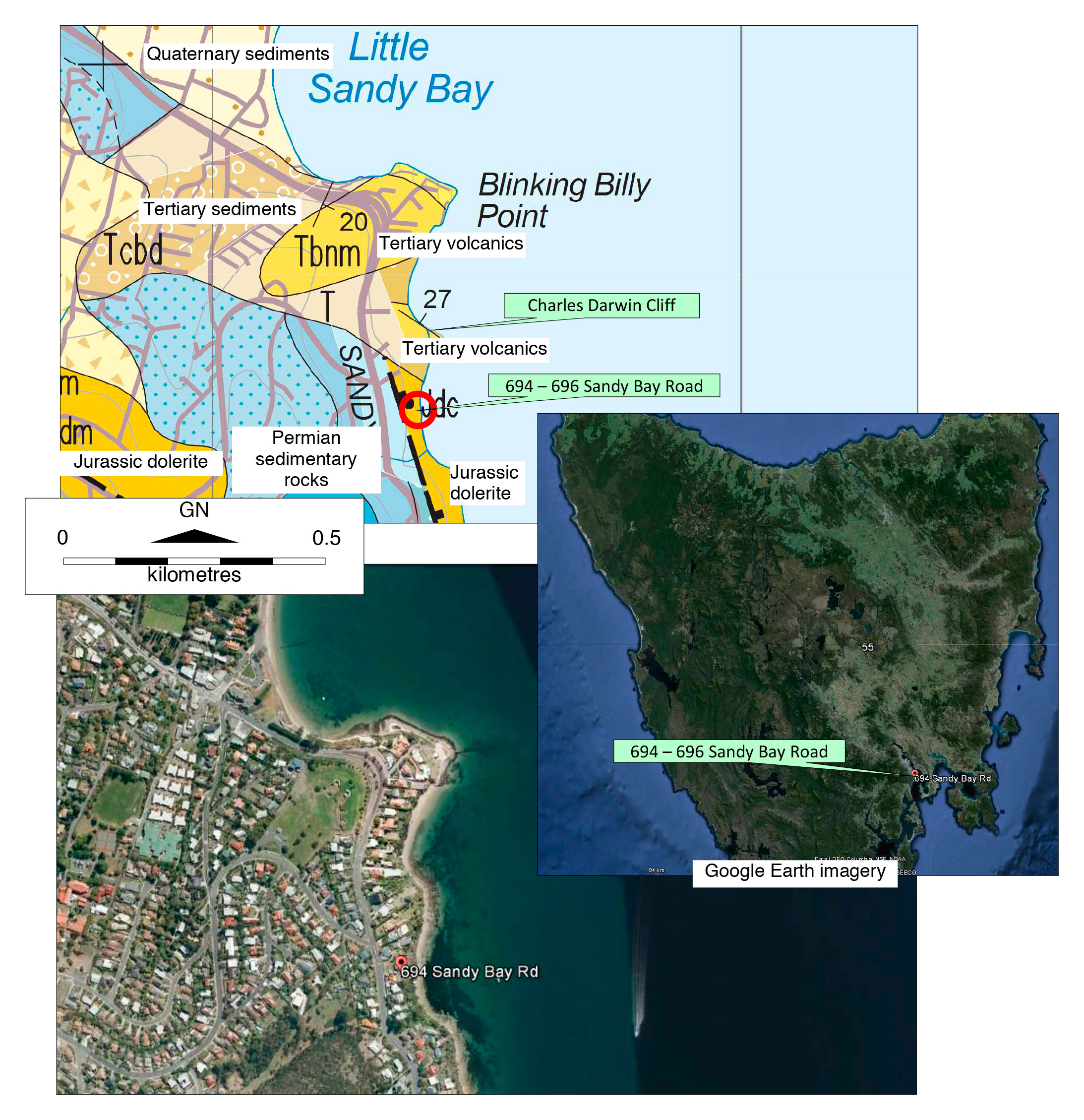
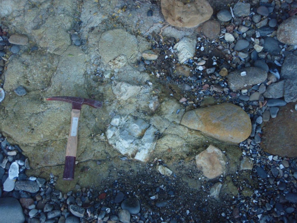
We look like having something similar in Tasmania – our own geo(tech)guides, specifically developed for our own slopes and varied geology.  Mineral Resources Tasmania has this month commissioned me to put together a series of geotechnical templates summarising in compact form useful geotechnical information for hillside development on each of the main geological units in Tasmania.

These will complement The Tasmanian Landslide Code: Geotechnical guidance for regulators and practitioners, my draft 2014 guidelines currently doing the regulators’ circuit.

Filed Under: Geotechnical Investigations, Landslides

Reinterpreting the coastal geology south of Charles Darwin Cliff at Sandy Bay, southern Tasmania

March 16, 2015 by Bill Cromer 1 Comment

Extremely weathered dolerite cobbles and boulders embedded in a dense to very dense matrix of extremely weathered and hydrothermally altered doleritic material are well exposed on the foreshore, and less well exposed on the steep coastal embankment, for several hundred metres south of the Tertiary volcanics at Charles Darwin Cliff at Sandy Bay.

The published 1:25,000 scale digital geological map of Hobart interprets the material as Jurassic-age dolerite bedrock – faulted against Parmeener Supergroup sedimentary rocks to the west. The location is close to where the NW – SE Cascades Fault Zone abuts the NNE – SSW Taroona Fault.

Geotechnical investigations in 2008 for proposed townhouses at 694 – 696 Sandy Bay Road show the published geology needs to be amended. The investigations included geological mapping, clearing an excavator access track across the 20m high coastal embankment, digging several excavator test pits, and drilling three diamond drill holes – two of them to sea level. View the drill hole logs. The interpreted geology (all materials are inferred to be Tertiary or younger) became somewhat clearer after extensive site excavations for the townhouses.

The first important observation was the presence of volcanogenic? sandstone with Permian-age clasts exposed after storm activity on the foreshore below 694 – 696 Sandy Bay Road. The sandstone apparently underlies doleritic material previously interpreted by others as dolerite bedrock. On the embankment above the volcanogenic? sandstone is a small outcrop of spheroidally- and extremely-weathered doleritic material in a doleritic silt/sand/gravel matrix, here re-interpreted as Tertiary-age boulder beds. The adjacent test pits and access track revealed sedimentary breccias and tuffaceous materials, and one of the diamond drill holes passed through two occurrences of volcanic ash separated by breccia. The third drill hole closer to Sandy Bay Road cored Permian-age bedrock from 6m, beneath 3m of volcanic ash underlying 3m of Tertiary?/Quaternary? breccia.

The geology in this small area is complicated. It is also unclear how far south along the coastal embankment and foreshore these Tertiary rocks extend, and whether sections are indeed in-situ dolerite bedrock. It is interesting to speculate whether the volcanic ash is the same material as (a) that interbedded with volcanic agglomerate at nearby Charles Darwin Cliff, and (b) the ash and agglomerate exposed on the foreshore and at the Taroona High School a few kilometres south. (I’ve also recently posted a blog reporting inferred volcanic ash between two Tertiary boulder beds in Glenorchy, 10km to the NNW.)

Geological map and aerial photograph of Charles Darwin Cliffs and surrounds Sandy Bay, Tasmania

View south from Blinking Billy Point in Sandy Bay towards the volcanic rocks on Charles Darwin Cliff at the end of the beach.

(Charles Darwin spent 12 days in Hobart in 1836. He did indeed walk this beach, and inspect the geology of the foreshore.)

View north towards the volcanic rocks on Charles Darwin Cliff.  The foreshore is littered with dolerite and sandstone cobbles. In the middle ground are large dolerite boulders.
View north towards the volcanic rocks on Charles Darwin Cliff. The foreshore is littered with dolerite and sandstone cobbles. The large boulders in the middle ground are of dolerite. At left is the coastal embankment leading up to 694 – 696 Sandy Bay Road, where detailed geotechnical investigations were conducted in 2008 for residential development.
Exposures of dolerite on the foreshore below Sandy Bay Road showing spheroidal weathering
It is understandable that exposures of dolerite like this on the foreshore below 694 Sandy Bay Road have been mapped by others as in-situ Jurassic dolerite bedrock. The spheroidal (“onion-skin”) weathering, the commonality of joint alignment and similarity of grain sizes across the 3m wide exposure all suggest undisturbed bedrock.
A detail of large spheroidally-weathered dolerite boulders in the intertidal zone, adjacent to the exposure interpreted as dolerite bedrock showing the doleritic matrix between the boulders.
A detail of large spheroidally-weathered dolerite boulders in the intertidal zone, adjacent to the exposure interpreted as dolerite bedrock (previous photo). Note the doleritic matrix between the boulders. Dolerite boulders larger than these occur further south on the foreshore, and also at the Hobart suburb of Taroona, where they are being winnowed out of Tertiary sediments.
Detail of a brecciated zone in doleritic material on the foreshore near Charles Darwin Cliff. Hydrothermal alteration like this is very common in the area.
A detail of a brecciated zone in doleritic material, on the foreshore south of 694 – 696 Sandy Bay Road. Hydrothermal alteration like this is very common in the area.
A view north towards Charles Darwin Cliff past large dolerite boulders in the middle ground. To the left of the boulders is an orange/brown/yellow outcrop exposed by storm waves.
A view north towards Charles Darwin Cliff in 2008, past the large dolerite boulders in the middle ground. To the left of the boulders, on the foreshore below 694 – 696 Sandy Bay Road, is an orange/brown/yellow outcrop exposed by storm waves. The outcrop is interpreted as volcanogenic sandstone with Permian sandstone clasts, of inferred Tertiary age.
A detail of volcanogenic sandstone with Permian sandstone clasts on the foreshore below  Sandy Bay Road, Tasmania.
A detail of volcanogenic sandstone with Permian sandstone clasts on the foreshore below 694 – 696 Sandy Bay Road. It appears to underlie the dolerite boulders, and is inferred to be Tertiary in age.
Detail of Permian sandstone clasts in volcanogenic sandstone on the foreshore south of Charles Darwin Cliffs, Sandy Bay, Tasmania
Detail of Permian sandstone clasts in volcanogenic sandstone below 694 – 696 Sandy Bay Road.
Extremely spheroidally weathered dolerite boulders, and an indurated Permian? sandstone/siltstone clast, all embedded in the same orange doleritic-textured matrix
Extremely spheroidally weathered dolerite boulders, and an indurated Permian? sandstone/siltstone clast, all embedded in the same orange doleritic-textured matrix, on the foreshore below 694 – 696 Sandy Bay Road.

Filed Under: Geology

New? aboriginal “relics” in southern Tasmania

March 5, 2015 by Bill Cromer Leave a Comment

In my travels around coastal Tasmania I often come across aboriginal middens – many (but not all) of which are probably included in the list of 12,000 or so cultural sites on the Aboriginal Heritage Register (AHR). [The AHR replaced the Tasmanian Aboriginal Site Index (TASI) in 2014.]

The Register is maintained by Aboriginal Heritage Tasmania (AHT) a division of the Department of Primary Industries, Parks, Water and Environment (DPIPWE). The fundamental aims of AHT “are to protect, conserve and promote Tasmania’s unique Aboriginal heritage for the benefit of present and future generations of Tasmanians.”

Physical evidence of aboriginal heritage is a “relic”, the management of which comes under the Aboriginal Relics Act 1975. This Act is likely to be replaced by the Aboriginal Heritage Protection Bill, which broadens the definition of “relics” to “Aboriginal objects” and “Aboriginal places”, each of which are of “significance to Aboriginal persons”.

I understand that members of the public don’t have direct access to the Register, so without formally approaching AHT it is not clear to me whether the following two aboriginal places have already been discovered and officially recorded:

  • Place #1 is a small near-coastal aboriginal quarry I stumbled on close to one of Hobart’s eastern suburbs. The quarried material is a light grey, very hard and flinty chert – possibly of Tertiary age – showing clear signs of scalloping and chipping.
  • Place #2 is an aboriginal worksite for quarried materials on a sandstone boulder beach in eastern Tasmania. The quarry is probably close by to the south. The quarried material is a dark grey, hard, indurated (baked) mudstone (some with light-olive siltstone laminations). Perhaps a few tonnes are scattered along about 50m of foreshore between high and low water marks. Apart from unworked angular blocks weighing up to a few kilograms, worked items are mainly smaller discarded flakes, chips and fragments, but some show good evidence of further hand-scalloping towards scrapers. Most have been tumbled about by wave action and are becoming rounded and smoothed. A few on the grassy verge out of reach of waves are more angular. A rounded strongly chipped hammer stone was also present. A single, angular tan-coloured scraper looks out of place among rounded cobbles. Was it recently dropped?

Very hard and flinty chert in one of Hobart’s eastern suburbs. The rock shows clear signs of scalloping and chipping.
Place #1. Very hard and flinty chert in one of Hobart’s eastern suburbs. The rock shows clear signs of scalloping and chipping.
Place #2.  On this Tasmanian east coast intertidal zone, all the dark rock fragments – all of them waterworn – are hard, baked mudstone relics carried from a nearby aboriginal quarry. Along this 50m or so stretch of foreshore, aborigines honed some of the rock fragments to tools, and discarded those seen here.
Place #2. On this Tasmanian east coast intertidal zone, all the dark rock fragments – all of them waterworn – are hard, baked mudstone relics carried from a nearby aboriginal quarry. Along this 50m or so stretch of foreshore, aborigines honed some of the rock fragments to tools, and discarded those seen here.
A discarded, moderately waterworn relic with scattered chips. A set of car keys has been used to show scale.
Place #2. A discarded, moderately waterworn relic with scattered chips.
A discarded, sharp-edged relic among sandstone cobbles and boulders above high water mark. A set of car keys has been used to indicate scale.
Place #2. A discarded, sharp-edged relic among sandstone cobbles and boulders above high water mark.
Discarded Aboriginal relics among sandstone cobbles and boulders near high water mark on a beach in eastern Tasmania. Carkeys used to show scale.
Place #2. Discarded relics among sandstone cobbles and boulders near high water mark.
A sharp-edged, tan-coloured scraper appears completely out of place in the intertidal zone on a southern Tasmania beach. A set of keys has been used to indicate scale.
Place #2. This sharp-edged, tan-coloured scraper appears completely out of place in the intertidal zone. Was it dropped recently?
 

Filed Under: General

An unusual boulder spit at Dennes Point on Bruny Island

March 5, 2015 by Bill Cromer Leave a Comment

I’m collaborating with expert coastal geologist/geomorphologist Chris Sharples to report on an unusual occurrence of boulders at the extreme northern tip of Bruny Island in southern Tasmania. The rounded, moderately-graded, mostly dolerite boulders (and cobbles) up to half a metre or so in size form an arcuate foreshore several metres high and extending a few hundred metres east from Dennes Point past Kellys Point.

Conservatively, some 15,000t of loose cobbles and boulders are exposed. About 10% of the material is Permian-age siltstone and sandstone cobbles and boulders, eroded from coastal cliffs and shore platforms to the east.

Recent coastal erosion has exposed dolerite boulders and cobbles present under sand on neighbouring beaches to the south, and a spit of dolerite boulders has formed between low and high water mark on Boulder Point.

Some say the boulder deposit is man-made – possibly ballast left by ships. A moment’s reflection shows this can’t be true: on the world stage, dolerite is a rare rock and is hardly likely to have been carried from overseas in large amounts by arriving ships; furthermore, departing vessels would either be in cargo or ballast, and if the latter, would hardly have dumped it just after leaving Hobart for the open sea. In any case, rounded boulders are scarcely a safe cargo in a rolling ship.

Dolerite boulders occur elsewhere on foreshores on the western side of the Derwent Estuary – notably from Taroona north to near Blinking Bill Point at Sandy Bay – where they are clearly being winnowed out of Tertiary-age boulder beds. On the northern tip of Bruny Island, Chris thinks the arcuate form of the boulder deposits wrapping around Kellys and Dennes Points is a rare recurved boulder spit, probably formed from winnowed boulders moved by storm swells refracting into the northern end of D’Entrecasteaux Channel.

Recurved sandy spits are a relatively common feature on the Tasmanian coast, but are rare in material as coarse as these boulders.

Locally, the boulders appear to be actively eroding from a weakly cemented conglomerate on Kellys Point. I think the conglomerate was formerly much more extensive, is probably Tertiary in age, and was the source material for the recurved spit.

Two maps showing the location of Dennes Point, the northern-most township on Bruny Island
The location of Dennes Point, the northern-most township on Bruny Island, Tasmania
Dennes Point, looking south from the entrance to D’Entrecasteaux Channel. The dolerite boulders forming the spit curving away along the channel stand several metres above high water mark.
Dennes Point, looking south from the entrance to D’Entrecasteaux Channel in February 2015. The dolerite boulders forming the spit curving away from the camera along the channel stand several metres above high water mark.
Dolerite boulders at Dennes Point, looking west from Kellys Point. The staff in the foreground is 5m long.
Dennes Point, looking west from Kellys Point. The dolerite boulders slope seawards at about 15°. The staff in the foreground is 5m long.
Dennes Point, looking west from Kellys Point showing the dolerite boulder deposit extending inland from the foreshore and disappearing beneath grass cover. The seawards slope here is about 250.
Dennes Point, looking west from Kellys Point. The dolerite boulder deposit extends inland from the foreshore, disappearing beneath grass cover and more recent Holocene aeolian sand. The seawards slope here is about 25°. The staff in the foreground is 3m long.
At Kellys Point, looking south to a weakly-cemented orange-brown boulder and cobble bed of rounded dolerite clasts, smaller angular sandstone and siltstone clasts, in a silt/sand matrix.
Kellys Point, looking south up to a weakly-cemented orange-brown boulder and cobble bed (a conglomerate) consisting of rounded dolerite clasts, and smaller angular sandstone and siltstone clasts, in a silt/sand matrix. Boulders are actively being eroded from the bank. I think the boulder bed might be Tertiary in age, that it was formerly much more extensive, and is the source of the material making up the recurved spit.
Detail of the (possibly) Tertiary conglomerate on Kellys Point, Bruny Island. A staff with values in decimetres is placed on the ground for scale.
Detail of the Tertiary? conglomerate on Kellys Point. The numbers on the staff are decimetres.
Looking east from Kellys Point, past the Tertiary? conglomerate at right, with sandstone and siltstone clasts on the foreshore. A 2.5m long staff is placed in the foreground for scale.
Looking east from Kellys Point, past the Tertiary? conglomerate at right. Sandstone and siltstone clasts on the foreshore become relatively more common to the east. The staff is 2.5m long.

Looking west towards Kellys Point, from a shore platform cut into Permian siltstone and sandstone showing the eastern extent of the dolerite boulders.
Looking west towards Kellys Point, from a shore platform cut into Permian siltstone and sandstone. This location marks the eastern extent of the dolerite boulders.

Filed Under: Vulnerable Coasts and Sea Levels

Foredunes and coastal development in Tasmania

March 5, 2015 by Bill Cromer Leave a Comment

Coastal planning and policy in Tasmania has been hindered by a use of ambiguous and undefined terminology in relevant coastal planning policy documents, notably the Tasmanian Coastal Policy (1996) and in some Local Government Planning schemes. The use of such terminology to define appropriate and inappropriate areas for coastal development has previously and will continue to result in vexatious planning disputes and poor coastal planning outcomes until it is corrected….

So says Chris Sharples in the Introduction to his discussion paper The problem of the use of ambiguous terms in Tasmanian coastal planning policy documents for defining appropriate coastal development zones (May 2012).

Inappropriate coastal landform terminology in Planning Schemes and legislation is holding back coastal development. Chris’s paper tries to sort out conflicting and out-of-date thinking, and it should be mandatory reading for all of us working in this area.

Chris has kindly allowed me to make his paper freely available as a downloadable pdf on this website (link below). Hopefully it will generate some comment.

Download Chris Sharples’ paper on coastal dune terminology in Tasmania (PDF Document 547kB)

Filed Under: Vulnerable Coasts and Sea Levels

A new occurrence of Tertiary boulder beds in Glenorchy, Tasmania

March 4, 2015 by Bill Cromer Leave a Comment

The published 1:25,000 scale digital geological map of the Hobart metropolitan area shows the OAK Tasmania’s Walkabout Industries site in Clydesdale Street, Glenorchy, and the neighbourhood, to be underlain by Jurassic-age dolerite.

New field evidence suggests the map needs to be amended.

In 2011 bulk excavations at OAK provided excellent exposures of weakly-consolidated, orange-brown boulder beds (see photo). The clasts in the material are almost entirely angular to rounded dolerite cobbles and boulders up to about 0.5m in size, with a few percent of smaller clasts of chert, and Parmeener Supergroup siltstone and sandstone.

In July 2013, a 9.6m deep auger-and-diamond drill hole sited adjacent to the excavation encountered 5.6m of similar doleritic boulder beds, overlying conglomerate composed entirely of Parmeener Supergroup sandstone and siltstone clasts to 50mm in a non-plastic silt/sand/gravel matrix. A band of pink/orange silty clay occurred in the conglomerate over the 5.90-6.05m depth interval. See the photo of the core, and the log of the hole.

I interpret the deposits in the excavation and drill hole to be Tertiary in age and of similar fault-scarp related origin to other boulder beds in the Hobart district. I think the thin horizon of silty clay in the drill hole could be volcanic ash. It is not clear how far the Tertiary deposits extend laterally from the OAK Tasmania site.

1:25000 scale geological map of glenorchy showing Permian, Quaternary, Tertiary and Jurassic dolerite zones
Geological map reference: Forsyth, S.M. and Clarke, M.J. (compilers) 1999. Digital Geological Atlas 1:25 000 Scale Series. Sheet 5225 Hobart

Excavations have exposed weakly-consolidated, orange-brown Tertiary boulder beds
Boulder beds with mostly dolerite clasts in an excavation at the OAK Tasmania’s Walkabout Industries site in Clydesdale Street, Glenorchy. The exposure is about 3m high.

Samples from each of the deposits found at different depths in the core from a drill hole in a Tertiary age boulder bed
The core from a 9.6m deep auger-and-diamond drill hole sited adjacent to the excavation. To 5.9m, the boulder beds are dominated by dolerite clasts. Below about 6.15m, the clasts are wholly Parmeener Supergroup sandstone and siltstone. I interpret the intervening pink/orange silty clay as volcanic ash, and the deposit as a whole as Tertiary in age.

Filed Under: Geotechnical Investigations

Earthquakes in Tasmania 1958 – 2014

March 3, 2015 by Bill Cromer Leave a Comment

I’ve recently been researching landslide triggers in Tasmania. Events which trigger landslides include unusually heavy rainfall events, and earthquakes.

Here’s a graph of some 860 earthquakes and their magnitudes recorded in the Tasmanian region over the period 1958 – 2014. It’s a picture of quiet earthquake periods lasting several years interrupted by years of much more intense activity.

The information is freely available on the Geoscience Australia website.

If you are able to access Google Earth (you will need the Google Earth software for PC, Mac or Linux), you can see the distribution of the same earthquakes on the satellite image of Tasmania in the .kmz file below. (I’m an IT amateur: David Winkle at A. S. Miner Geotechnical set up the .kmz file for me.)

Instructions for viewing the file are as follows:

  1. Click on the Google Earth file – satellite image of distribution of earthquakes in Tasmania. Depending on your browser, this will download the file or instantly open it in Google Earth. In the former case, you’ll need to locate the file in your file manager and then open it in Google Earth.
  2. Left-clicking on an earthquake symbol on the satellite image provides more detailed information.

A very similar map of earthquake epicentres in the Tasmanian region appears in the beautifully comprehensive Geological Evolution of Tasmania (2014) published by the Tasmanian Division of the Geological Society of Australia.

A graph plotting earthquakes in Tasmania from 1958 to 2014, with magnitude on the y-axis and date along the x-axis.
Tasmanian Earthquakes 1958 – 2014 (source: Geoscience Australia)

Information about earthquake magnitudes is summarised in the two tables following. (The estimated number of earthquakes each year in the first table is the worldwide number.) The Tasmanian earthquakes range in magnitude class from (less than) Minor to Light, with two quakes (in January 1958 and May 1969) of magnitudes 5.3 and 5.2 respectively edging into the Moderate class. Earthquake activity not shown on the graph and map included many small and some large quakes in northeastern Tasmania during 1883 – 1885.

Earthquake Magnitude Scale

Magnitude Earthquake Effects Estimated Number
Each Year
2.5 or less Usually not felt, but can be recorded by seismograph. 900,000
2.5 to 5.4 Often felt, but only causes minor damage. 30,000
5.5 to 6.0 Slight damage to buildings and other structures. 500
6.1 to 6.9 May cause a lot of damage in very populated areas. 100
7.0 to 7.9 Major earthquake. Serious damage. 20
8.0 or greater Great earthquake. Can totally destroy communities near the epicenter. One every 5 to 10 years

Earthquake Magnitude Classes

Earthquakes are also classified in categories ranging from minor to great, depending on their magnitude.

Class Magnitude
Great 8 or more
Major 7 – 7.9
Strong 6 – 6.9
Moderate 5 – 5.9
Light 4 – 4.9
Minor 3 -3.9

Filed Under: Geology

Subscribe to my newsletter
Profile of Bill Cromer

Geologist, thylacine author, tennis player [more about me].

Contact Bill

  • Email
  • Google+
  • Twitter

PH 0408 122 127

INT +61 408 122 127

Recent Posts

  • Codes in the 2015 Tasmanian Interim Planning Scheme
  • Flowchart for applying the Tasmanian Acid Sulphate Soils Code
  • Flowchart for applying the Tasmanian Coastal Erosion Hazard Code
  • Tasmanian Landslide Code
  • Tasmanian On-site Wastewater Management Code

News Archive

View full archive

News Archive by Month

  • August 2016 (3)
  • May 2016 (2)
  • August 2015 (1)
  • June 2015 (2)
  • March 2015 (7)
  • February 2015 (1)
  • July 2014 (2)
  • June 2014 (1)
  • March 2014 (1)
  • December 2013 (2)
  • November 2013 (1)
  • October 2013 (6)
  • July 2013 (3)
  • May 2013 (2)

Professional Services

  • Geotechnical Investigations
  • Soil Testing
  • Groundwater
  • Wastewater
  • Coasts

Products

  • Cromer Hydrogeological Calculators
  • Cromer Constant Head Field Permeameter
  • Trench® Wastewater Software

News Categories

  • Apps & Software
  • Cromer Permeameter
  • General
  • Geology
  • Geotechnical Investigations
  • Groundwater
  • Landslides
  • Thylacine
  • Vulnerable Coasts and Sea Levels
  • Wastewater
  • Home
  • Professional Services
  • Products
  • About
  • News
  • Publications
  • Contact me

Contact

  • Email
  • Google+
  • Twitter

PH 0408 122 127

INT +61 408 122 127

Copyright ©2025 Bill Cromer. All Rights Reserved.